- Expeditions
By Region
By Month
By Grade
By Height
- Treks
By Region
By Month
By Grade
By Height
- UK & Alpine
By Category
By Grade
- Schools
- Hire
- News
- Shop
Clothing
Footwear
Equipment
Expedition

- Contact


Ecuador Volcanoes
Saturday 5th January
We headed towards Chimborazo via the town of Riobamba. Upon arrival at Riobamba we checked into the hotel and found that it was one of the nicest places that we have stayed. Just after check in there was a parade along the street in front of the hotel with fireworks flying in all directions before the procession of candle holding people behind the bombediers truck and brass band. This was a bit unexpected.
After a leisurely start on Saturday 5th January, we drove up to the start point for our attempt on Chimborazo. We managed to drive off-road all of the way up to 4,800m (about the height of Mont Blanc). Here we chillaxed, ate some pizza, had lunch, left an audio blog and just generally lingered over the space of two hours or so to let our bodies re-adjust to the elevation. Chimborazo was occassionally coming into view in between bouts of cloud/mist and it looked a formidable challange.
The summit of Chimborazo is further from the centre of the core of our planet that any other bit of land (due to the equatorial bulge) – it is about 2km further from the centre of the Earth than Everest (8,848m above sea level) despite it’s height only being 6,310m (20,702ft above sea level).
We took some photos and Chasqui pointed out on my digital camera screen the route that we were to attempt. The El Castillo Route is about a 40 degrees angle (with a short section of 70 degrees) and is graded grade II / PD and is about 1300m of elevation gain from the Edward Whymper refuge. Chimborazo looked much harder than our guidebook photo due to the retreat of its glaciers.
Although we had fleeting glances of Chimborazo it was marginal whether we would get a weather window in the coming 5 days and the freezing level on the mountain was very high (ie the mountain was very warm).
We headed up to the Edward Whymper hut at 5,000m at about 12:30pm to wait and see what the weather would do and to position ourselves for a summit push.
We quickly nipped up to the hut at 5,000m. On route we saw plenty of ‘Vicuna’ (a wild relative of the llama) in the ‘arenal’ (sand) – the area is so arid that some people compare this area to the Altiplano of Bolivia.
We found a small room upstairs in the hut, laid out our camping mats and sleeping bags and relaxed for a short while. We had an early dinner and went to bed at about 4pm(?) ready for having a breakfast at about 9pm and setting off up the hill by 10pm. Whilst asleep, Chasqui woke us up and revised breakfast time to 10pm as the weather had changed. There was very heavy rain on the hut roof occurring between at least 7pm and 8pm and the hut was engulfed in cloud. After the rain finished, there was a continual drizzle onto the hut. The conditions were reminding us of those that we faced at the commencement of the Cotopaxi ascent.
When we got up for breakfast at 10pm we discussed the conditions with Chasqui and he discussed them with the guides of the one other group present in the refuge that night. This group were from Colorado.
My concern was that the heavy rain earlier in the night could have resulted in significant snow accumulations higher up the mountain that were not consolidated on slopes of 30 degrees plus and hence could present a significant avalanche hazard and that the rain/drizzle could lead to an increased risk of stonefall on the mountain. The guides debated conditions and said to us all to wait till midnight to see if conditions improved.
The guides decided to push on up the mountain and see what conditions were like higher up. Leaving at midnight there was little chance of safely reaching the summit and getting back down to safety before the sun was too high in the sky. I decided to remain at the refuge, not get soaked and not waste energy on not getting a summit although it could have been beneficial to get to know the route somewhat. I headed back to my sleeping bag on the hard sleeping mat on the refuge floor for some broken sleep.
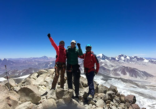
George wanted to have a go at it and he headed up the mountain with Chasqui. After about an hour of effort, George and Chasqui had made it up to approx 5300m which is still well below El Castillo and just getting to the region known as El Corridor. This is the same height as was recorded on the memorials for some mountaineers who had died on Chimborazo.
Due to the conditions being experienced they decided to turn around. There was water running above and below sections of ice. Stones/rocks being stood on were continually sliding away under their feet and one of the guides from the other party had been struck on the helmet by some small stonefall. All this before getting onto the glacier properly. Two hours after George and Chasqui had set off they returned safely to the refuge. Later on the other group returned. The conditions had got colder and the drizzle/rain was now falling around the hut as snow, and the other group had experienced a lot of verglas on the rocks during their descent.
In the light of the new morning, Chimborazo exposed her beauty and looked very do-able despite the warm of conditions (see picture above). George went up to some low lying snow pack patches and noted that there was significant slab build up which sheered very easily (ie the avalanche risk was very high) – if we had pushed for the summit then we would have had to risk being avalanched during our descent in the morning daylight. We had definitely made the right call not to go for the summit.
We had a reserve day on our programme for attempting Chimborazo. We looked again at the weather information. The freezing level for the following evening was going to be even higher so this meant that the conditions were even less favourable for attempting Chimborazo. Basically, the mountain needs to be freezing from at least 5,000m and above to do it safely.
The conditions weren’t right so we made the hard decision to abandon our attempt on Chimborazo.
Technically we had all been further from the centre of the core of the Earth than the summit of Everest is. However it was disappointing to have not reached Chimborazo’s summit. Better to retreat and allow us to attempt it another day than to never be able to attempt it again.
Hence on the morning of Sunday 6th December, we descended down to the Toyota truck, left another audio blog and cracked open a couple of beers.
22nd December 2012 – A unique experience among the world’s highest volcanoes
Saturday 5th January
We headed towards Chimborazo via the town of Riobamba. Upon arrival at Riobamba we checked into the hotel and found that it was one of the nicest places that we have stayed. Just after check in there was a parade along the street in front of the hotel with fireworks flying in all directions before the procession of candle holding people behind the bombediers truck and brass band. This was a bit unexpected.
After a leisurely start on Saturday 5th January, we drove up to the start point for our attempt on Chimborazo. We managed to drive off-road all of the way up to 4,800m (about the height of Mont Blanc).
Here we chillaxed, ate some pizza, had lunch, left an audio blog and just generally lingered over the space of two hours or so to let our bodies re-adjust to the elevation. Chimborazo was occassionally coming into view in between bouts of cloud/mist and it looked a formidable challange.
The summit of Chimborazo is further from the centre of the core of our planet that any other bit of land (due to the equatorial bulge) – it is about 2km further from the centre of the Earth than Everest (8,848m above sea level) despite it’s height only being 6,310m (20,702ft above sea level).
We took some photos and Chasqui pointed out on my digital camera screen the route that we were to attempt. The El Castillo Route is about a 40 degrees angle (with a short section of 70 degrees) and is graded grade II / PD and is about 1300m of elevation gain from the Edward Whymper refuge.
Chimborazo looked much harder than our guidebook photo due to the retreat of its glaciers.
Although we had fleeting glances of Chimborazo it was marginal whether we would get a weather window in the coming 5 days and the freezing level on the mountain was very high (ie the mountain was very warm).
We headed up to the Edward Whymper hut at 5,000m at about 12:30pm to wait and see what the weather would do and to position ourselves for a summit push.
We quickly nipped up to the hut at 5,000m. On route we saw plenty of ‘Vicuna’ (a wild relative of the llama) in the ‘arenal’ (sand) – the area is so arid that some people compare this area to the Altiplano of Bolivia.
We found a small room upstairs in the hut, laid out our camping mats and sleeping bags and relaxed for a short while. We had an early dinner and went to bed at about 4pm(?) ready for having a breakfast at about 9pm and setting off up the hill by 10pm.
Whilst asleep, Chasqui woke us up and revised breakfast time to 10pm as the weather had changed. There was very heavy rain on the hut roof occurring between at least 7pm and 8pm and the hut was engulfed in cloud. After the rain finished, there was a continual drizzle onto the hut.
The conditions were reminding us of those that we faced at the commencement of the Cotopaxi ascent.
When we got up for breakfast at 10pm we discussed the conditions with Chasqui and he discussed them with the guides of the one other group present in the refuge that night. This group were from Colorado.
My concern was that the heavy rain earlier in the night could have resulted in significant snow accumulations higher up the mountain that were not consolidated on slopes of 30 degrees plus and hence could present a significant avalanche hazard and that the rain/drizzle could lead to an increased risk of stonefall on the mountain. The guides debated conditions and said to us all to wait till midnight to see if conditions improved.
The guides decided to push on up the mountain and see what conditions were like higher up. Leaving at midnight there was little chance of safely reaching the summit and getting back down to safety before the sun was too high in the sky. I decided to remain at the refuge, not get soaked and not waste energy on not getting a summit although it could have been beneficial to get to know the route somewhat. I headed back to my sleeping bag on the hard sleeping mat on the refuge floor for some broken sleep.
George wanted to have a go at it and he headed up the mountain with Chasqui. After about an hour of effort, George and Chasqui had made it up to approx 5300m which is still well below El Castillo and just getting to the region known as El Corridor. This is the same height as was recorded on the memorials for some mountaineers who had died on Chimborazo.
Due to the conditions being experienced they decided to turn around. There was water running above and below sections of ice. Stones/rocks being stood on were continually sliding away under their feet and one of the guides from the other party had been struck on the helmet by some small stonefall. All this before getting onto the glacier properly. Two hours after George and Chasqui had set off they returned safely to the refuge. Later on the other group returned. The conditions had got colder and the drizzle/rain was now falling around the hut as snow, and the other group had experienced a lot of verglas on the rocks during their descent.
In the light of the new morning, Chimborazo exposed her beauty and looked very do-able despite the warm of conditions (see picture above). George went up to some low lying snow pack patches and noted that there was significant slab build up which sheered very easily (ie the avalanche risk was very high) – if we had pushed for the summit then we would have had to risk being avalanched during our descent in the morning daylight. We had definitely made the right call not to go for the summit.
We had a reserve day on our programme for attempting Chimborazo. We looked again at the weather information. The freezing level for the following evening was going to be even higher so this meant that the conditions were even less favourable for attempting Chimborazo. Basically, the mountain needs to be freezing from at least 5,000m and above to do it safely.
The conditions weren’t right so we made the hard decision to abandon our attempt on Chimborazo.
Technically we had all been further from the centre of the core of the Earth than the summit of Everest is. However it was disappointing to have not reached Chimborazo’s summit. Better to retreat and allow us to attempt it another day than to never be able to attempt it again.
Hence on the morning of Sunday 6th December, we descended down to the Toyota truck, left another audio blog and cracked open a couple of beers.
Friday 4th January was a scheduled rest day to help with recovery from Cotopaxi. For this “rest day”, we headed out to see the Quilotoa volcanic crater which has a massive lake filling the crater.
We drove close to the top of the volcano’s crater – an impressive 3900m. The view over the crater was impressive. The diameter of this volcano’s crater is some 3.15 km. Chasqui, our guide, suggested that we hike down into the crater to the water’s edge. We nipped down to the water’s edge. It was only a descent of 1000ft (about 330m).
When we got to the water’s edge we could see bubbles of gas breaking at the surface. This sulphurous gas appearance helped reinforce the fact that this is still an active volcano.
We took an alternative path to regain the 1000ft of height to get back up to the crater rim. I was low on energy today, partly from skipping breakfast but more so for having a hangover. Opps. We eventually got back up to the crater rim and we took numerous photos en route of this amazing place.
We stopped for lunch at a small restaurant at the crater rim then started our onwards journey. We had not been going long when we had to stop the truck for a brief while. There had been some rock fall onto the road and construction teams were working to clear the debris off of the road. After the short delay we continued on our journey.
Today was the last day that Angharad Roberts was spending with the team. George and I are heading on to, hopefully, attempt Chimborazo (weather/conditions permitting) whilst Angharad is nipping out to the Galapagos Islands for a week of diving.
At an intermediate point, we met a car that had been pre-organised for collecting Angharad to take her back to Quito for her flights to the Galapagos Islands. We said our goodbyes and George, Chasqui and I are now continuing our journey south to Riobamba tonight. The weather is not looking promising for Chimborazo at present, but we can always hope for some improvement. Have a great weekend everyone.
2nd January: We headed towards Cotopaxi to commence our attempt on her summit. Cotopaxi is the world’s highest active volcano.
The itinerary was for us to proceed directly up to a mountain hut at 4800m (parking at 4600m and walking up), where we would rest before a night time ascent of Cotopaxi. We had some sleep before dinner, had dinner then got about another 4 hours sleep. We woke just before 11pm, had breakfast, got ourselves ready for the hill and by midnight we were in the Toyota truck heading up to the Cotopaxi car park at 4600m.
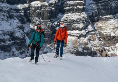
At about 00:35 on 3rd January we started walking up towards the hut. There was snow on the ground at altitudes lower than the car park – normally there isn’t much snow on the ground in the lower reaches of Cotopaxi. When we set off up Cotopaxi we were in the cloud, there was a light wind blowing and it was drizzling.
After 45 mins, we reached the hut, nipped in briefly and concluded that we had made the right call to stay at a lower hut. After a short rest from the weather by 1:30am we were underway again up the mountain. We gradually made progress up Cotopaxi despite the conditions but as we got higher and higher up the volcano the conditions continued to deteriorate. As we progressed up, a thick layer of ice was enveloping each of us so some movements became harder due to needing to break the ice on our exteriors.
We pushed on, and by a height of about 5400m a decision was made for the safety of the group to turn around and abort the summit bid. We still had about 500m vertically and 1.6km horizontally to cover to get to the summit. At this stage we were all covered in about half an inch (about 1cm) of ice.
Parties on the mountain ahead of us had already turned around and we were the last ones making a summit bid as most parties didn’t like the conditions. No-one summitted Cotopaxi that night.
We descended rapidly down Cotopaxi back to the car park at 4600m and reached the safety of the Toyota truck at 4:15am. As we defrosted all of our clothing and equipment became drenched and some electronics were casualties.
We went back to the refuge where we had slept before the summit bid and went back to sleep. After several hours sleep, we re-assessed conditions and decided that conditions had not sufficiently improved for another summit bid that night. Very few people, if any, have successfully reached the top of Cotopaxi in the last 7-10 days due to the weather.
Having attempted to dry our kit to some extent, we packed up and had a visit to Limpiopungo laguna near Cotopaxi. We had a stroll around this laguna then headed onwards to our programmed accommodation for the evening of 3rd January. We had commiseration drinks and food before heading off to bed.
Depending on how we get on with Chimborazo and if the weather on Cotopaxi improves then we might get another crack at it on this expedition.
1st January: We could not see volcano Illinizas due to low cloud and drizzle, however it was anticipated that there would be some snow and ice on it so we carried up our big boots and crampons.
We proceeded up a path towards a refuge at 4700m altitude where we stopped for some lunch and a rest from the wind and drizzle. After about an hour we continued up towards Iliniza Norte following the normal route up the south east ridge. As the ridge narrowed below a false summit pyramid we traversed right on sandy ledges. This section is known as the Paso de Muerte (death pass). This traverse gave us access to the base of the summit block and here we scrambled up gullies with loose rocks to the summit where we found an iron cross marking the summit. At the summit, we had no view but for some excitement George set off a firework.
We scrambled back down the gullies to the pass then followed the scree route down off of the volcano. This provided a fairly rapid descent on loose scree – a bit like going down the great stone shoot of Sgurr Alasdair on Skye but for a lot longer and traversing the volcano as we descended steeply.
We reached the Toyota truck again after 9 hours and 15 minutes, having covered 19.9km and 1,247m of ascent. Once we were all in the truck we then drove to “Cuello de Luna” hotel where we had dinner, started drying out our gear and began packing for our imminent attempt on Cotopaxi (the world’s highest active volcano).
The 1st of January 2013 was a good start to the year with us achieving our goal of doing a 5,116m high volcano. Happy new year everyone and we hope that you have a great 2013.
On 29th December we were to have an acclimatisation day, involving a short walk to the nearby glacier and undertaking glacier / ice-axe / crampon training (or refamiliarisation). We had been told by our guide that we would be out for no more than 2 hours, back at the refuge for lunch then relax for a midnight breakfast and a 1am start up Cayambe. Due to the rapid increase in living/sleeping altitude most of us had headaches associated with altitude.
I don’t know where the time went, but we didn’t set off up the hill until 2am. It was a beautiful star-lit night supported by the glowing moon. We could see Orion, the Southern Cross and the watercarrier (aquarius stars) very clearly.
After the initial walk up rock slopes, by 3:30am we were donning our crampons and heading up the glaciated slopes of Cayambe. We were joined for this mountain by a second guide (Rafielle).
At 4:30am, having already crossed numerous crevasse. Ang and George were roped up with our main guide and I was paired with Rafielle. Rafielle and I headed up the mountain followed by the others.
As the hours passed, the summit of Cayambe continued to look impenetrable, far away, and I was wondering how we would get up it. We followed a series of snow ridges that broke up the glaciated terrain and then climbed a short gully (Scottish grade I) to give us access to a steep snow slope that had to be climbed (Scottish grade II). Once we had reached the top of this slope, we traversed the mountain for a bit, then gained some more height, and crossed a snow bridge that gave amazing views of the seracs and glaciated summit. It was then a short final push to the summit.
Rafielle and I reached the summit at 8:30am and the others joined us 15 minutes later. We were getting cold so we didn’t hang around on the 5,790m (18,996 feet) summit. Before shooting off, I congratulated George on him achieving yet another new personal high point (he’d previously only been as high as Mont Blanc du Tacul (about 4,248m) in France).
Rafielle and I made rapid progress down Cayambe and after only 2 hours descent we were back at the refuge. The others joined us later.
The 19,000ft summit of Cayambe is the highest point that I have reached during 2012 and it was certainly hard work.
We are now on our way to Quito for tonight (30th Dec) and tomorrow we travel onwards to another hut so that we can position ourselves to attempt Iliniza volcano’s north top on the 1st January 2013.
We wish everyone a happy new year whenever it occurs in your timezone.
On 28th December, we had a rest day which involved a little bit of sightseeing and, more importantly, we travelled up to the mountain refuge at the base of Cayambe.
The refuge is located at an elevation of 4600m and is accessed via probably one of the scariest landrover tracks that I have ever been on. Thankfully we arrived there without incident.
The height of this refuge was a massive increase in our sleeping elevation and as such we all felt the effects of the increased altitude – just carrying bags to the sleeping area was strenuous, leaving us out of breath. It was a much nicer refuge than many that I have stayed at in the Alps.
27th December saw us undertaking an ascent of the slopes of Imbabura as part of further acclimatisation ahead of our main big volcanic aims in Ecuador.
When we set out from a height of about 3350m the summit of Imbabura was shrouded in cloud and we were hopeful that it might clear.
We knew that we had a big day ahead of us as Imbabura rises to a height of 4621m so we had the equiavlent of climbing a Ben Nevis at altitude.
The acclimatisation trek started by following a track towards some settlements however we soon turned off of this track onto rough vegetated ground and proceeded upwards.
There was a trampled route that we used to proceed up the unrelenting slopes. As we gained height the views across the valley were beautiful however the top of the volcano was still shrouded in thick cloud so we had no idea of what we were undertaking.
The route had been following a ridge line until we met a very steep section where the path then did a steep rising traverse to regain the ridge at about 4260m.
Here we applied even more layers of clothing as it was cold in the wind and cloud.
We proceeded along the narrow ridge and soon it just began to become steeper and steeper. So steep in fact that we had to put away our walking poles and start scrambling up steep, damp, occasionally loose, rock.
As we gained height, the wind seemed to continue increasing in strength however we continued to climb up into the clouds.
After about 150m of vertical scrambling, the route turned into a narrow ridge again. I would describe this section of the ascent as being comparable to scrambling along the Aonach Eagach ridge in Scotland – it was airy but we could not see the drops into the crater or down the other side of the volcano.
After less than 5 hours of physical effort we reached a flat area with a couple of cairns, then scrambled a little further to reach a top of Imbabura that had been marked by previous people with paint and claimed as their summit. This point was at 00.26161N 078.17862W and a height of 4571m.
We had set off walking at 7:30am and it was now 12:15. We had gained over 1250m of height.
Peakbagger.com gives a trekkers summit and a true summit. We were about 200m horizontally and 10m vertically from the trekkers summit and 800m horizontally from the true summit (which was at the other side of the crater rim (i.e. At least 1.5km away following the rim circumference). To get to the trekkers summit involved proceeding along a damp, potentially slippy, knife edge ridge and the wind had increased further. It was the group consensus not to proceed any further, as we had achieved our aim of more acclimatisation.
We had to be very careful in descent as we had to down climb all of the sections that we had previously climbed up. We never knew the full extent of the drop beneath us.
Eventually we got back onto the steep path and gradually made our descent. There were two other groups on Imbabura with us and neither group had even made it as far to commence the scrambling so we were pleased to have made a good attempt on the volcano.
As we descended we were rewarded with fleeting glimpses of Cayambe which is another volcano that we wish to attempt. Our guide is concerned with how low the snow is on Cayambe and hence the snow higher up may be deep. We will assess this in person soon.
Once we got back to our truck, Imbabura’s summit was briefly clear of cloud before quickly hiding from view again.
It had been a good acclimatisation walk and good training for me. We proceeded back down to our accommodation, had a shower then went into Ibarra city for dinner. We all had Ecuadorian fish and chips washed down with beer.
Today, Friday 28th December is a rest day but no doubt we will have some new news to report by the end of the day.
26th December: There are many many volcanoes in Ecuador and Fuya Fuya had been selected as the first one for us to attempt as it helps us gradually acclimatise to higher and higher elevations.
It is billed as an “easy” volcanic top to reach the summit of. If you read accounts of people ascending this summit then in most cases this is true, it is easy and you just gradually plod up a path through the paramo vegetation.
When we reached this summit in patchy cloud, we could not see any land higher in the vicinity and thought that we were at the top after only 2 hours hiking. So we sent an audio blog, however when we then checked our GPS devices, we were more than 400m away from the true summit given on the Peak Bagger website and a little bit lower than the true summit.
Prior to heading out to Ecuador, I had done some research and the true summit of Fuya Fuya is located at 0.13349 N 78.29346 W.
The tourist trekker summit that is reached by most parties is at 0.13466 N 78.28998 W, but little mention is made of this trekker summit not being the true summit. Thankfully our guide was switched on and we headed over to where our GPSs indicated that the true summit was. It was obvious on the ground that few people venture along the ridge to the true summit as the path was significantly less worn and muddy.
We proceeded along the ridge towards the true summit and were faced with a tower of rock which was passed on the left hand side with some steep exposed scrambling along a line that others had previously taken. We then came to a notch in the ridge which involved a couple of exposed moves that stretched our limbs and after across this we were soon at the true summit.
On the summit, the clouds parted and we had good views all around, including towards the trekker’s summit (which has a prominence of about 70m).
We then proceeded back along the ridge and crossed at the notch again. This time, instead of retracing our steps along the ridge we down climbed into the gully on our left (in descent) at the notch. This steep gully had a slightly worn route that allowed us to traverse after a while and regain the ridge below the section of steep scrambling.
We then descended Fuya Fuya by the normal route back down to the lake where we had parked. As we descended, it started to rain and we were happy to be back on a path rather than on steep exposed rock/mud.
We are now heading towards tonight’s accommodation and will be having an early night for an early start for an attempt on another (higher) volcano tomorrow.
23rd December: George and I have arrived in the Southern Hemisphere town of Quito in Ecuador. We were met at Quito airport by our guide who is called Chasqui. He seems a nice guy and on the way to our hotel (Hotel San Francisco de Quito) we stopped at his house for a beer. Once we got to the hotel, we met up with the rest of the team (who’d arrived the day before us).
Just been out to eat some food at a local Ecuador backstreet cafe/restaurant – don’t really know what we’ve eaten but it tasted ok. The plan for tomorrow is to acclimatise at Quito’s altitude of 2850m, visit the old city, and later on travel to the small Indian town of Otavalo at stay at about 3000m altitude.
Hope that your Christmas preps are going well. Merry Christmas. Bob


