- Expeditions
By Region
By Month
By Grade
By Height
- Treks
By Region
By Month
By Grade
By Height
- UK & Alpine
By Category
By Grade
- Schools
- Hire
- News
- Shop
Clothing
Footwear
Equipment
Expedition

- Contact


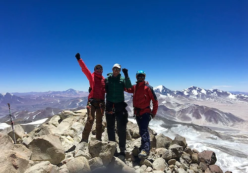
K2/Broad Peak Expedition 2004
Team Leader: Dave Pritt
The Team: Chris Mothersdale Stuart Peacock Ralph Greenway Phurpa Ridar Bhote Mingma Nura Sherpa
Two years have passed since the decision was made to attempt K2. We had summitted on Everest on the 16th May 2002 and had vowed never to set foot on another 8000m peak after the months of discomfort and the debilitating effect of altitude on mind and body….
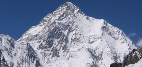
We arrived in Kathmandu a few days later already thinking of the next mountain, K2 was the ultimate if scary option.In three weeks we fly to Pakistan, to Islamabad and all the reading and dreaming and training is at an end and the hard work will start in earnest. In this unknown city we will have to go through the rigmarole of finding our freight at the airport, not a short process normally, signing the last minute papers necessary to move onwards and deal with all the little problems associated with moving four climbers and equipment to Skardu and then on to the Broad peak base camp. We hope to fly to Skardu but may have to drive if the weather is poor. When we arrive at Skardu we will need to employ a number of porters and mules to carry the equipment for the eight to ten days that it will take to get firstly to the Broad Peak Base camp. We will walk to Askole and from there along the Braldu River to the Boltoro Glacier until we reach Concordiaat 4720m. A short walk up the Godwin Austin Glacier towards K2 will bring us to the base of Broad Peak and base camp (4900m) for the first objective. Broad Peak is the 12th highest mountain in the world at 8047m. It was first climbed in 1957 in ‘alpine style’ by an Austrian team. They were thwarted on the first attempt by a false summit and had to return a second time to climb it. We plan to place camps at 5400m, 6250m and finally at 7200m. From here we will push up to the summit ridge and follow this over the fore summit fixing some pinnacle sections to the summit. Although the mountain is an ‘easier’ 8000m mountain the summit day will still be in excess of 12 hours and will be a real test at altitude. K2 is the second highest mountain in the world at 8616m and is variously called the ‘killer’ mountain, ‘the climbers’ mountain, and the ‘most difficult’ of the 8000m mountains. It gets this reputation from the weather, which is unpredictable, the technical difficulties, objective dangers such as stone fall and avalanche and the problems associated with cold and altitude. It has not been climbed for three years. This is our second objective.We will establish Base camp at about 5200m on the Boltoro glacier before pushing the route up the mountain to Camp 1 at 6100m. Above this camp is the notorious ‘Bills’ or ‘Houses’ Chimney, which is the crux technically. This is climbed to camp 2 at 6700m, which lies below the Black Pyramid – a broken, steep rocky section that is often very difficult if the conditions are poor. Camp 3 above this lies on snow at about 7200m, although the position of this camp varies from year to year and from team to team. The shoulder is a long snowy glacier with some large crevasses which although not technically difficult is very tiring and in poor weather route finding up and down this section can be very difficult if not impossible. Camp 4 lies as high on this, anywhere between 7600m and 8000m. Once this camp has been established the team can push on to attempt the summit. Very early in the morning (11.00pm/12.00am) we will set out up snow slopes to the ‘bottle neck’. This is a narrow gully about 100m in length, which gradually steepens and is at an altitude of about 8300m. In dry years it can be very steep and be 80 degrees. This ends at a hanging glacier, which must be traversed under until the final summit slopes can be gained. The sting in the tail is a rocky step just before the summit. If all goes well we would hope to be on the summit in the early afternoon. This is the plan! Chris Mothersdale May 2004.
23/07/04: All indications from the various weather reports were that the weather was going to improve up to the weekend when Saturday, Sunday, and Monday would be clear of clouds, snow and high winds. By the time we set out at 5.00 am on Wednesday the 21st July the forecast had changed again and Sunday – our intended summit day was looking more doubtful. We set off across the glacier all going well and zig zagged our way through the seracs to the bottom of the route. Crampons and axe out we started the 900m climb to camp 1 up gradually steepening snow slopes and onwards to the bottom of the fixed line at about 5600m. I was going well to start with but gradually slowed and it was at about 5750m when I decided for a number of reasons to turn round and try again the following day. The others, Dave, Stu, Ralph, Purba Sherpa, Sonam Sherpa and Ibrahim Rustum continued and arrived at camp 1 around mid day all going strongly. In no hurry I descended to about 5500m when I heard a noise and on looking up saw an avalanche approaching fast. I had no time to do any thing and was soon fighting to get to the surface, axe in hand trying to break out I was hit by another faster avalanche which pushed my axe into my face cutting my nose. I fought to the surface again and managed to ride on the surface to the bottom of the slope some 200m lower. Shaken and bruised but otherwise ok I made my way back to Base Camp very slowly after informing Dave. The avalanche had shot past Sonam and Ibrahim higher up but fortunately they were attached to a fixed line and were to one side. Back at camp I relayed the forecast to Dave on the mountain which seemed now to suggest poor weather and high winds on Friday and on Sunday afternoon. They decided to set off on Thursday but were soon engulfed in spindrift and wind and when I reported that the weather did not look to be improving the decision was made to descend back to camp 1 from about 6400m. Most of the team made it back down to base camp that day except for Sonam who climbed to camp 2 to collect equipment and then descended to ABC and Purba who dumped a load at ABC then climbed back up to camp 1 to collect tents before returning to ABC to spend the night with Sonam – a massive effort! They returned back on Friday morning with Ibrahim who had gone up to meet them and help them with a load. We are all back at base camp and after much discussion between our selves and other teams have decide to ask the porters to collect us for the walk out. We feel that after our success on Broad Peak in very difficult conditions, the present conditions on K2 and future poor weather that this decision is the correct one for us, but it has not been easy to reach. Chris Mothersdale
19/07/04: Following our success on Broad Peak, the team are now poised ready to make a summit bid on K2. Our plans are to leave base camp on Wednesday for Camp 1 with the aim to summit on Sunday after moving through four camps. The weather forecast is looking good. Dave Pritt
15/07/04: Hi all, now reporting from K2 Base Camp. The move up the glacier went well, we have a good position next to the Korean clean-up team. They have been working hard clearing rubbish from camp 3 down and on the glacier.There is still a bit of discussion regarding Broad Peak, if teams made the main summit or the pre-summit. From the route description given by the Swiss guide Kari, and time taken, the Sherpas and I seem to think we could have made the main summit, however we just can’t be sure. Sonam & Purba spotted some Tibetan Flags in the snow on the summit, which I didn’t see. I also recorded a GPS waypoint just off the summit which I hoped would line up with one of our maps. When we checked out the Longitude & Latitude the Northing placed us as far as the main summit, however the Easting placed us 300 yds west of the ridge in free space, which could be a fault of the GPS or the map. At the end of the day we cannot guarantee with any certainty that it was the main or pre-summit, especially as the cloud had come in. Although it’s only a few meters difference in height and people still bag the mountain on the pre-summit, it would be nice to know one way or the other, not that it changes much. We’ll just have to be content with where we got to wherever that may be. The weather is due to start taking a turn for the worse later on tomorrow. We are planning to make a cache at camp 1 before the weather sets in. All being well the weather will be clearing by Tuesday. The Swiss have made good progress on the mountain and have established camp 4 via a new more direct route from camp 3. We are all well and I’m certainly glad of the weather coming in to rest properly, ready for making real progress on the mountain next week. Thankfully tent spaces have become available at camps 1 & 2, which was a concern early on in the trip, so things are looking good so far. No false summits to cloud this one !!! Regards, Stu
08/07/04: Adventure Peak Team Members Stuart Peacock and Sherpas Phurba Ridar Bhote and Mingma Nuru Sherpa summited Broad Peak today at 2.45pm. Ralph Greenway and high altitude porter Ibraham reached 7860m. Well done to all. Expedition Leader Dave Pritt and Chris Mothersdale turned round at 6700m due to extremely cold feet having just purchased Scarpa Phantom 8000m boots which proved to be very poor. Has anyone else had similar experiences?
03/07/04: We spent this morning having a play with the new oxygen system, checking how it all fits together and trying out the nasal canular & mask. The plan so far is that in the next couple of days we will go back up the hill with the intention of getting to camp 3 and then possibly make a summit attempt. I have decided to take the oxygen up with me and make my decision weather to use it at camp 3. Although Broad Peak is only just over 8000m (8047m), we have only had a short time at altitude, so oxygen may be necessary if an attempt is made so soon. Otherwise we will stay at Camp 3 for a night and then descend to BC in order to make a later summit bid. Regards, Stu.
02/07/04: The weather was still reasonable, so I made it a bit of a wash day clothes & self, which was sorely needed. Did a little bit of light reading and generally just chilled out.The porters give us some entertainment in the evening with more songs accompanied this time with not just barrel drums but with a three piece goat skin timpani set. It appears that not a single bit of the poor old Billie has been wasted.
01/07/04: We spent two nights at camp 2 before heading back down to Base Camp for 3 days rest. The descent wasn’t too bad, however the sun was very hot and it made for thirsty work. The fixed line in the couloirs was fixed a bit too tight so abseiling was not practical and required some trusty hand wrapping to descend.It was good to get back to BC and gorge ourselves on Pringles & Pepperami and a bottle of Pepsi.
30/06/04: The Sherpas made a carry & help fix line towards camp 3 with the Swiss (c7000m – 7200m); unfortunately deep snow prevented them getting any further than 6700m, so a stash was made there. We had a bit of a lazy day adjusting to the altitude. We all had a bit of a short walk, Ralph & myself pushed up to 6415m at which point the snow ridge angle eases off.
29/06/04: Another early start, this time heading to camp 2 at 6200m. Again due to the previous week’s snow conditions, most of the fixed line was buried. The terrain is mainly 45 – 50 degree snow slopes, with the odd steep section. Navigation down would be very difficult in bad weather if there were no ropes; thankfully folk are clearing the ropes when they head down. I got into camp at 10.00am; gps height read just over 6300m. Again the next problem was to find suitable places for the tents. This we finally managed after 3 hours digging and clearing. Once again space for tents on the ridge is few and far between, teams have to spread out thin, looking for any sheltered areas.
28/06/04: Today we finally set off for camp 1 on broad peak. The weather was good; we had breakfast at 4.00am, a very unsociable hour of the day. There were a few teams that were heading up today. We had some delays due to anchors on some of the fixed line. The route itself goes up through reasonably steep couloirs, topping out at around 5200m. Camp 1 was said to be at 5400m, however it was obvious from the top of the couloirs that it was much higher. From the couloirs we headed up a 45 degree snow field, there was a lot of avalanche debris from the heavy snows the previous week. It was only after two thirds of the way up we found the fixed line which had been buried by the avalanches. I finally rolled into camp at 10.00am, a bit dehydrated due to my camelback freezing in the early hours.Dave had been ahead and when I arrived I helped to clear and enlarge the tent platforms. We just managed to get 3 cramped tents onto our ledge; space at camp 1 is a bit of a premium especially with so many teams on the mountain this year.
24/06/04: The weather is still bad. Apparently the worst weather in a long time. The forecast for the next few days is more of the same. Dave arrived in camp at 2:00pm so the team is now complete. However our neatly laid out mess tent now looks like a bomb site with all of Dave’s kit. The good news is the laptop is now fully up and running. All we can do now is sit and wait for the good weather and for the avalanches to subside. So lots of drinking, eating, reading and mickey-taking of Dave due to the lack of views he had on the walk in. We’ve already shown him what the Trango Towers look like, which impressed him no end. Regards, Stu.
23/06/04: Today’s plan was for us to go up to camp 1 and pitch the tents. Unfortunately there have been very heavy snows. This has made the mountain very dangerous and avalanches have coming down all around. Thankfully we can see them from the safety of our camp.
22/06/04: We walked to K2 base camp to help us with acclimatisation, this got us to a height of 5000m. Sunam, Perber & Ebrehiem went up to camp 1 with a carry of tents and then cleared a platform ready for when we move up. There are a lot of teams on both mountains and finding tent space is posing the biggest problem next to the weather.
21/06/04: Yesterday we arrived at Broad Peak Base Camp. The Base Camps have been established on a central moraine scar on the Godwin-Austen Glacier near the start of the route. The height of BC is 4825m so not far off the top of Mont Blanc. The clouds have been hugging close to K2 and Broad Peak and we appear to Be level with the cloud base so we can’t see much the majority of the time. Although the cloud did lift yesterday evening to reveal Broad Peak in all its glory. We could see the ridge line from camp 2, to where camp 3 will ae positioned. We could also see the col to which the final summit ridge is attained. It all looks a long way away from down here.K2 also revealed most of itself, only the summit was in cloud, due to the strong winds hitting the south face and blowing ice crystals up and over the summit to form a long plume on the opposite side.We stood for quite some time looking at the route and pondering what it will be like to be up there, not quite believing that we are now here in front of these two giants.Last night we had a lot of snow, thankfully today was a rest day. Again the clouds hang low and the snow comes and goes. We have sorted through the barrel, checking tents etc.We found the barrel with the pepperami & the branston pickle in it, so we had a bit of side treat with our dinner. The food has been excellent throughout the trip. However we did feel a little bit guilty for the goat which had been walked all the way up to BC only to meet its demise in time for our tea last night !! It’s nearly enough to make you veggie. We have 2 chickens remaining from 12. They appear to be seeking refuge under the table in the mess tent. I suspect they won’t see the week out.
19/06/04: We were told by Samander our Hushe Treks rep that the days walk to Urdukas would be the hardest day. Travelling over undulating moraine for most of the journey. It actually turned out to be not so bad and we arrived at Udukas in good time. The camp is situated on terraced levels with the impressive summit of Urdukas peak behind. The only problem we have had at these camps is the dust, it gets into everything and dries your throat. However it’s nice to have decent facilities on the approach to base camp. On the 19th we had a slightly later start of 6.00am still far too early for my liking. Today was to be an easier day,travelling over a slightly more level Baltoro Glacier. The sun was blasting down on us but the clouds seemed to be clinging to some of the surrounding peaks. Masherbrum kept it’s head in the clouds, Mustagh came into view for a spell. Eventually we rounded a corner and got our first sight of Gasherbrum 4, at first only a silhouette in the mist, eventually revealing itself through the clouds. To its right Mitre Peak, too its left Golden Peak. Barely visible through the cloud further left the summit of Broad Peak. After arriving at Goro 2, our camp on the glacier for the night. We relaxed and looked at some of the surrounding peaks. Suddenly there was an almighty crash and an avalanche came down from one of the peaks. Very impressive from the safety of our camp several kilometres away. Tomorrow all being well we shall at Broad Peak base camp. Although it requires another early start, which I’m not looking forward to. Dave is about 4 days behind us, today should be is first day trekking from Askole. Regards,Stu.
17/06/04: Well after travelling overland to Skardu and then by jeep to Askole, we started our trek towards Broad Peak base camp on the 15th. Askole itself wasn’t a particularly pleasant place to stay, but was fine for one night. There has been a lot of work done to the other camps as far as Urdukas, in that they have good sanitation and bins to separate waste as well as camp management. Askole is due to be developed for next years season. The trek to the Jhola camp takes about 5.5 hours with a 1.5 hours dinner stop, this was made at the junction with the Biafo Glacier. The weather turned a bit miserable and eve started to rain a little bit. Arriving at the camp we were amazed to see how much effort has been made to prevent further damage to the environment. Toilets, washing facilities, solar charged lighting for the night, recycle bins and an incinerator as well as replantation of trees. In the evening the clouds lifted and we spent some time looking at a very impressive peak on the other side of the valley, working out possible routes on to the knife edge summit ridge. On the 16th we had another early start on our trek to Paju. This was a slightly shorter day. It started with some spots of rain, and it looked like it was going to get worse. Fortunately it didn’t and soon the clouds broke, before we new it we were in the baking sun. Just after passing a military encampment we stopped for another delicious dinner, after which we ad the final two hour walk into camp. Paju sits amongst a cluster of trees, so is well sheltered from the sun. Paju is at a height of 3480m , here we are having a rest day for the porters and allowing us time to acclimatise. We’re still having problems charging the laptop. Hopefully this will be sorted when Dave joins us at base camp. It will take another 3 days to reach base camp. Tomorrow we head up to Urdukas, which should take around 7 hours. En route, weather dependant, we should see some of the most technically challenging mountains in the world. Ralph will no doubt be looking for future base jumping possibilities
14/06/04: We are now camped above the river at Askole. It took us 7 hours to drive the 106km from Skardu and looking back at the tracks we have come up I think we made good time. It now feels like we are on our way, we have left the fields behind and are now surrounded by snow capped peaks. On asking the guides what the local peaks are they tell us not to worry they are only small mountains, most are unnamed. The map shows them as around 5500m.On looking back at the last few days, we were disappointed to be driving in to Skardu not flying (weather and road closures all conspired against us and meant the flights were over booked), but I believe the 3 long days we’ve spent on the road have been worth it for the places we’ve seen along our way. Flying out would be nice though. Tomorrow we start our week long trek to base camp. Ralph.
13/06/04: Skardu is the last of the big towns on our route and the end of the tarmac roads, that we seem to have spent so much of the last few days on. Here we swapped our mini bus for jeeps. The team spent the morning sorting final admin and doing some last minute shopping in the bazaar, before heading out for a relaxing afternoon exploring the local area. Our liaison office Captain Hassan did us proud by managing to convince the local officials to open their offices and by getting all our paper work signed. Not bad for a Sunday………..
12/06/04: We breakfasted at 9:00am and were relieved to see Chris feeling much better. After breakfast the hotel shop owner was trying to get us to buy some maps of the Karakorum for $12 each. Well Let’s just say Poker-Faced Mothersdale drives a hard bargain and we left the shop owner in tears, having bought 4 maps for $5 each. We restocked with water and then set out on our 7 hour journey to Skardu, along the way stopping to get some pictures of The North Face of Nanga Parbat and surrounding areas. The landscape is quite arid with high mountains, albeit foothills, on both sides of the River Indus. Along the waywe had a quick stop by a monument which marks the point at which the 3 great mountain ranges of the Hindu Kush, Himalyas & Karakorum meet. Then it was back in our bus to Tricko where we planned to have our pack lunches. We passed through Shangri La, which is just outside Skardu. Here the Indus opens up into what was up until last year a big lake, now it is mostly sandbanks, although still very picturesque. Finally we reached our journeys end. We are staying at the Pioneer hotel which is a nice hotel, although we lost the electricity a couple of times last night and so started our evening meal with head torches. While still feeling enthusiastic and organised we sorted out the barrels and personal kit so that none weighed more than 25kg, which is the limit for the porters. We also met the Cook & Pakistani High Altitude Porter who will be joining us on our merry journey. Stu
11/06/04: We left Islamabad at 10:00am and headed out on our 450km, 14 hour journey to Chillas part way along the Karakorum Highway. The road is better than expected although still a little bit bumpy in places. At one point we stopped for some photos looking down on to the Indus and here we had our first victim to succumb to the dodgy tummy. Chris was sick a few times, this we have put down to him midnight snacking at the Conference room on his floor in the hotel after we had been out for a drink. Those nasty can !!!! Don’t worry though we’ve put him on Nil food by mouth for the day and just fluids. We reached Balham at 6:00pm and stopped for dinner, Chris flaked out and stayed to Pepsi, while Ralph and myself opted for Chicken Chow mein. The food has been excellent so far, although I’m sure we’re all going to have our turn at being ill… it’s only fair! We had the choice to stay at Bisham with Chris feeling ill, but Chris insisted we carry on to Chillas, even though it was still another 4 hours’ drive. Well Chris did a sterling job of keeping what was left of his stomach contents in his stomach. Amazingly we reached Chillas right on time, to the very minute, at 12 midnight. We were staying at the Chillas Inn and upon arriving were treated to a late, but welcome hot buffet tea, while Chris retreated to his room. The hotel itself was very pleasant, a far cry from the 5 star luxury in Islamabad, but good never the less. PS. We only found out, late on the way to Chillas, that the driver had only had 2 hours sleep since the previous day, this unnerved us somewhat while travelling along the precipitous cliffs, but it has to be said he did a sterling job.

About Dave Pritt
Dave Pritt is the Director of Adventure Peaks. With over 30 years of mountaineering feats, he is a very experienced high altitude mountaineer who has led expeditions to K2, Broad Peak and five Everest expeditions. Dave has completed the 7 summits, led an expedition to Ski the South Pole Last Degree, Satopanth in India and in 2007 he guided Ian McKeever to break the world record for the seven summits in 156 days. He is lucky enough to have climbed on the majority of our advertised peaks, but the Tien Shan remains his favourite destination.